
 Continue with onX Maps
 Continue with Facebook


 Particularly Special Place


 Intermediate
Intermediate
Intermediate
 Intermediate
Local Club: Ossipee Valley Snowmobile Club (OVSC)
Land Manager: USFS - White Mountain National Forest Office
 Mount Osceola Out and Back
5.9 mi 9.4 km • 1,952' Up 595.09 m Up • 1,952' Down 595.07 m Down
 Arethusa Falls Frankenstein Cliff Loop
4.9 mi 7.9 km • 1,521' Up 463.67 m Up • 1,539' Down 469.21 m Down
Jackson, NH
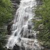
 Arethusa Falls Out and Back
2.9 mi 4.7 km • 868' Up 264.68 m Up • 869' Down 264.78 m Down
Rattlesnake
1.8 mi 2.8 km • 344' Up 104.84 m Up • 346' Down 105.33 m Down
 Holderness, NH
 The Presidential Traverse
19.0 mi 30.5 km • 7,705' Up 2348.41 m Up • 7,131' Down 2173.59 m Down
Gorham, NH
Franconia Ridge Loop
8.3 mi 13.4 km • 3,566' Up 1086.87 m Up • 3,564' Down 1086.35 m Down
Lincoln, NH


0 Comments