
 Continue with onX Maps
 Continue with Facebook


 Particularly Special Place


 Intermediate
Intermediate
Intermediate
 Intermediate
Land Manager: USFS - Chattahoochee-Oconee National Forest
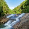
 Bridal Veil Falls
1.8 mi 2.9 km • 593' Up 180.76 m Up • 593' Down 180.8 m Down
 Clayton, GA
 Anna Ruby Falls Trail #15
1.0 mi 1.5 km • 221' Up 67.38 m Up • 221' Down 67.25 m Down
 Raven Cliffs Falls
5.5 mi 8.8 km • 895' Up 272.91 m Up • 895' Down 272.79 m Down
 Cleveland, GA
Neels Gap - Lake Winfield Scott Traverse
Cleveland, GA
Neels Gap - Lake Winfield Scott Traverse
6.2 mi 10.0 km • 1,416' Up 431.71 m Up • 1,615' Down 492.29 m Down
Blairsv…, GA
Brasstown Bald via Jack's Gap
5.8 mi 9.3 km • 2,179' Up 664.28 m Up • 2,179' Down 664.01 m Down
Hiawassee, GA
Coosa Backcountry
12.7 mi 20.4 km • 3,326' Up 1013.7 m Up • 3,311' Down 1009.17 m Down
Blairsv…, GA


0 Comments