
 Continue with onX Maps
 Continue with Facebook


 Particularly Special Place


 Intermediate
Intermediate
Intermediate
 Intermediate
Land Manager: USFS - Columbia River Gorge National Scenic Area Office
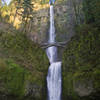
 Multnomah Falls Out and Back
2.7 mi 4.3 km • 868' Up 264.56 m Up • 868' Down 264.48 m Down

 Bridal…, OR
 Angel's Rest Lookout
4.1 mi 6.6 km • 1,441' Up 439.21 m Up • 1,439' Down 438.72 m Down
Bridal…, OR
Hamilton Mountain Loop
7.1 mi 11.5 km • 2,169' Up 660.96 m Up • 2,167' Down 660.65 m Down
Stevenson, WA
Oxbow Highlights
5.5 mi 8.8 km • 447' Up 136.37 m Up • 451' Down 137.48 m Down
Grouse Vista - Sturgeon Rock - Silver Star Loop
8.7 mi 14.0 km • 2,273' Up 692.85 m Up • 2,266' Down 690.6 m Down
Venersborg, WA
Dry Creek Falls
4.4 mi 7.1 km • 734' Up 223.66 m Up • 734' Down 223.58 m Down


0 Comments