Dogs No Dogs

Features
Birding · Fall Colors · Views · Wildflowers · Wildlife
Overview
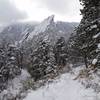
A classic for Boulder mountain hikers, Green Mountain delivers a lot of vertical without truly leaving town. Your chances of seeing a professional ultra runner on any given day are pretty good. With the right gear and clothing, it can be done on any day of the year. In addition to the route given here, there are many other routes up Green Mountain that give this mountain a lot of different variety, from fast and flowing trails to steep and rooted trail straight up punishing inclines.
Need to Know
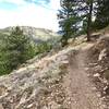
The upper sections of the mountain on the ascent and descent hold ice from November to early April. Microspikes are highly advised during this time. There are several small creek crossings on the loop but they're never too deep or fast, and getting water may be unreliable most of the time. The trail near creek crossings generally gets icy before other parts of the trail.
There are no dogs allowed on upper
E.M. Greenman Trail.
Description
From the
Gregory Canyon parking lot, take the
Ranger Trail South where you get a little bit of rest from steeper climbing as the newly reconstructed trail cruises along a ravine. Eventually the trail winds its way up to the Northwest ridge of Green Mountain, which is occasionally quite windy. The trail returns to steep climbing as you head up the ridge, eventually reaching a series of switchbacks up to the west ridge of Green Mountain. The
Ranger Trail ends at a junction. Turn East and head up the final few hundred feet, which are steep, rocky stairs and logs.
At the summit, enjoy the fantastic views to the East of Boulder and downtown Denver, and to the West, the Continental Divide, Rocky Mountain National Park, Indian Peaks Wilderness, several 14ers, and ski areas.
From the summit, head North down the
E.M. Greenman Trail, which immediately drops into some steep and rocky switchbacks. The trail mellows out to almost flat near the
Saddle Rock Trail/
E.M. Greenman Trail junction. From the trail junction, take the
Saddle Rock Trail to the Northeast down more technical and rocky terrain generally between -20% and -30%. After a particularly rocky section, you need to come to a short ladder to get down a section of trail that was destroyed by flooding in September, 2013. Either descend the ladder or go down the left side on the steep slope.
After the ladder, continue down heavily rooted trail and rock stairs to the
Amphitheater Trail/
Saddle Rock Trail junction. It doesn't matter which way you go from here, since both trails descend to the
Gregory Canyon parking lot in about the same distance.
Dogs are not allowed on the upper section of the
E.M. Greenman Trail (i.e. the southeast side of the summit), but are allowed on the
Ranger Trail/
Gregory Canyon /
Long Canyon Trail side of the loop. The sections allowing dogs follow standard off-leash OSMP rules.
Flora & Fauna
This route offers hikers a great variety of flora and fauna to stimulate the senses along the way. Beginning in the grassy, magpie filled meadows of Chautauqua Park, you'll transition into a ponderosa and lodgepole forest. As you gain elevation, evidence of the transformation to a more montane zone will become evident. As with all trails in this region, be aware that mountain lions and black bears inhabit the area.
History & Background
There's a sighting disk that will help you identify the many tall mountains to the west of Green Mountain. The plaque was placed there in 1929 by the CU Hiking Club.
The
E.M. Greenman Trail is named after Ernest "Dad" Greenman, who was part of a prominent Boulder family in early 1900s, and developed many of the trails and climbing routes in this area.
In September 2013, several sections of trail were heavily damaged or destroyed by flooding. Some sections of the
Ranger Trail are newly constructed, and there is a ladder on the
Saddle Rock Trail.
Contacts
Shared By:
Eli Zabielski
with improvements
by Nick Barendregt

 Continue with onX Maps
 Continue with Facebook


 Particularly Special Place


 Difficult

 4.6 (111)


 Minor Issues


1 Comment