Dogs Unknown

Features
Birding · Historical Significance · River/Creek · Swimming · Views · Wildflowers

There are no restrooms or services. Fellow passersby will be few, if any. Cell service is spotty at best. If you opt to travel in this area, be fully self-reliant. Always carry a water filter and full containers of water. As a low-elevation hike, hot temperatures are common in the spring, summer, and fall. Combined with south-facing slopes, lack of shade, and infrequent access to water, heat exhaustion and stroke are very real dangers on this trail. Be aware. Be prepared.
Need to Know
This trail will challenge even the most highly skilled outdoors person. Its remoteness necessitates a satellite communication device; and, its wild trail status is reason for users to be highly competent in navigation skills. Although accessible in summer, use of the trail is not recommended due to hot temperatures. There are several river crossings which must be forded; there are no bridges across the South Fork River. These crossings may be impossible or hazardous most of the year, notably in winter and spring. A good rule-of-thumb for crossing is when the water level is 80 cubic per second or less as measured at the river gauge in Wawona, CA.
Description
For the experienced, the South Fork Trail is a reminder of why we respect nature; for the novice, build your skills first before attempting this challenge. The South Fork of the Merced River Gorge is not a place to be unprepared-but those that are will be gifted wildness, peace, and beauty. Although one could hike the trail uphill, the recommended direction is from the east (Wawona Road in Yosemite National Park) to the west (exiting onto Highway 140), as the trail is generally downhill and easier to spot. It's a 21.8-mile "point-to-point" trip.
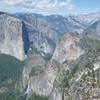
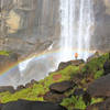
The main attraction of the hike is the South Fork of the Merced River, a designated "Wild and Scenic River," which flows out of Yosemite's high country. Its fabled pools filled with mountain runoff attract anglers and swimmers alike, and the difficulty of reaching them only increases their mystery. There are several camps of old spread out along the trail, teasing glimpses of days when pack mules and horses traversed the trail, including Bishop Camp, Kistler, Grapevine, Zip Creek, Peachtree Bar, Devil's Gulch, Sim's Horsecamp and Hite's Cove (a famous gold-rush era mining town).
History: While the present trail is a collection of various trail segments constructed at different times, for different reasons, and with different standards, it is fair to say that paths made by indigenous peoples and wildlife were its foundation. Early pioneer uses were for mining, early routes to Yosemite, and fishing and hunting; the relics of such can still be seen by the discerning eye; pioneer trails can be dated to the 1850s and 1860s.
Hiking & Backpacking: On paper, it appears that one could hike or run the trail in a day, but that is an unreasonable assumption given the condition of the trail, which is unsigned, crosses multiple creeks and rivers, is blocked by brush, downed trees, and at several locations simply vanishes into the terrain. Before the fires, floods and tree mortality, and associated treefall, one could comfortably do a 3-day, 2-night backpack. Under current conditions, folks should plan for 5 days and 4-nights. Easy-to-access campsites are rare in the central 10-mile core, Peachtree Bar and downstream of Zip Creek being two options.
Equestrians: The trail is presently not in any condition for these users.
Mountain Bikes: It's not really feasible to ride a mountain bike on this trail.
Flora & Fauna
Starting from the Wawona Road in Yosemite, the trail threads through a mixed oak-pine forest. By the time you arrive at the South Fork River, 4.5 miles later, the area is predominately oak woodland in the canyons and chaparral on the slopes between, with some pines along the river-bank. As one travels further west and lower in elevation, the majority of the slopes are covered in grass, pockets of oak trees and solitary California Buckeyes, as well as chaparral. Raptors, including hawks and eagles, as well as great blue herons may be seen. Bears, mountain lions and coyotes also live in the area. Be watchful for rattlesnakes too. Use of bear containers is highly recommended to keep the bears wild and safe.
Contacts
Shared By:
Mariposa Trails

 Continue with onX Maps
 Continue with Facebook


 Particularly Special Place


 Very Difficult

 Dewey Point

 Yosemit…, CA
 Mono Meadow Sampler
 Half Dome


3 Comments