Dogs Unknown

Features
Views
Overview
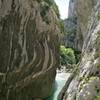
A couple nice views along the way lead to a prominent point at the end with big views.
Description
Park in Saint Julien du Verdon (well-signed), then hike back up north along the road for about a quarter mile, to where the road hangs a 90 degree left turn. Continue straight on a small lane, passing the sign for this hike and looking for small yellow paint markings. The lane turns smaller, and then to a singletrack.
The mid-section is somewhat steep, but the top flattens out again. Though there are views along the way, the one at the end is worth the push.
Shared By:
Nick Wilder

 Continue with onX Maps
 Continue with Facebook


 Particularly Special Place


 Intermediate


0 Comments