
 Continue with onX Maps
 Continue with Facebook


 Particularly Special Place


 Intermediate
Intermediate
Intermediate
 Intermediate
Land Manager: Coconino County and the City of Flagstaff
 SP Crater
1.9 mi 3.0 km • 685' Up 208.66 m Up • 682' Down 207.92 m Down

 Flagstaff, AZ
 O'Leary Peak
10.0 mi 16.2 km • 1,955' Up 595.85 m Up • 1,955' Down 595.91 m Down
Kachina Peaks Wilderness Loop
23.2 mi 37.3 km • 4,535' Up 1382.37 m Up • 4,537' Down 1383 m Down
 Sycamore Rim
10.9 mi 17.6 km • 1,129' Up 344.23 m Up • 1,128' Down 343.68 m Down
Parks, AZ
 Campbell Mesa
10.2 mi 16.4 km • 499' Up 152.07 m Up • 502' Down 152.99 m Down
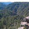
Walnut Canyon Rim
15.0 mi 24.2 km • 974' Up 296.86 m Up • 974' Down 296.8 m Down


1 Comment