
 Continue with onX Maps
 Continue with Facebook


 Particularly Special Place


 Difficult
Difficult
Difficult
 Difficult
Land Manager: White River National Forest - Maroon Bells
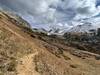
 Four Pass Loop
27.1 mi 43.6 km • 7,265' Up 2214.42 m Up • 7,266' Down 2214.53 m Down
 Snowmas…, CO
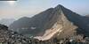
 Maroon Peak Trail
2.1 mi 3.3 km • 3,697' Up 1126.94 m Up • 65' Down 19.85 m Down
 Snowmas…, CO
 Rustler Gulch Out and Back
7.7 mi 12.3 km • 1,271' Up 387.47 m Up • 1,271' Down 387.49 m Down
Crested…, CO
 Copper Creek and Copper Lake Hike
11.8 mi 19.0 km • 2,132' Up 649.76 m Up • 2,132' Down 649.69 m Down
Crested…, CO
Crested Butte to Maroon Bells Trailhead
17.0 mi 27.3 km • 2,911' Up 887.23 m Up • 2,939' Down 895.78 m Down
Crested…, CO
Castle and Conundrum
12.0 mi 19.3 km • 4,299' Up 1310.31 m Up • 4,298' Down 1309.91 m Down
Aspen, CO


0 Comments