
 Continue with onX Maps
 Continue with Facebook


 Particularly Special Place


 Intermediate
Intermediate
Intermediate
 Intermediate
Land Manager: USFS - White River - Eagle-Holy Cross Ranger District
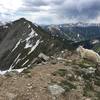
 Ten-Mile Range Traverse
19.0 mi 30.6 km • 7,047' Up 2148.01 m Up • 6,525' Down 1988.74 m Down

 Frisco, CO
 Upper Slate Lake
22.7 mi 36.5 km • 4,091' Up 1247.06 m Up • 4,091' Down 1246.96 m Down
Silvert…, CO
 Summit Cove: Soda Creek & Groovy Uvi
3.2 mi 5.2 km • 350' Up 106.79 m Up • 350' Down 106.53 m Down
Keystone, CO
Bighorn Creek
7.3 mi 11.7 km • 2,167' Up 660.35 m Up • 2,176' Down 663.18 m Down
Vail, CO
Gore Range to Wheeler Lakes
7.1 mi 11.4 km • 1,423' Up 433.71 m Up • 1,423' Down 433.75 m Down
 Grizzly Peak
5.6 mi 9.0 km • 2,381' Up 725.84 m Up • 2,379' Down 725.22 m Down
Keystone, CO


0 Comments