Hiking Project Logo

A very steep trail with loose footing to the summit of Elk Mountain and beyond with numerous viewpoints along the way


Your Rating: Rating Rating Rating Rating Rating      Clear Rating
Your Difficulty:
Your Favorites: Add To-Do · Your List
Zoom in to see details
Map Key

3.9

Miles

6.3

KM

Point to Point

3,096' 944 m

High

1,023' 312 m

Low

2,470' 753 m

Up

598' 182 m

Down

15%

Avg Grade (8°)

93%

Max Grade (43°)

Dogs Leashed

Features Fall Colors · Views · Wildflowers

Need to Know

The ascent up Elk Mountain is very steep and has slippery footing, but limited exposure. Not all hikers will enjoy this

Description

The road leading to parking for Elk Mountain is the same for the Elk Creek Campground. It is a single-lane dirt road that should be accessible for any vehicle and has pull-offs for passing other cars. The first parking area is only for the campground. There are two more parking areas that access this trail and should provide plenty of space to park.

You'll need to take the Wilson River Trail a short distance (0.1 miles) to access Elk Mountain Trail. The intersections were well signed and included distances. Elk Mountain Trail begins in earnest - it will be clear how steep this trail can be from the very beginning. There are essentially no switchbacks and the trail has lots of small, loose rock, so be careful not to slide down the mountain. There are some sections that may require your hands for support. This makes the trail a fun scramble for some hikers, but one to avoid for others.

Along the way to the top, you'll pass multiple excellent viewpoints (mostly facing south-ish). There is a semi-false-summit that you need to descend from before the final push to the top of Elk Mountain (stay to the left). At the top, there is a box with a registry and a sign proclaiming the elevation for a "did it" photo-op.

The trail continues onward for those looking to do a loop with Elk Creek Trail or Kings Mountain. However, the steepest part of the trail is the descent off of Elk Mountain to the southwest. Take your time on this scramble down. A few more semi-scrambles will be necessary before the trail suddenly becomes a smooth, easy former forest/logging road. The gentle grades and big switchbacks on the second half of the trail couldn't be more different from the first half!

A few more view points keep things interesting, including a rescue helicopter landing area, before you come to an intersection with Kings Mountain Trail and then end at Elk Creek Trail, not far from the actual high point of the ridge.

Flora & Fauna

Wildflowers and fall colors in their respective seasons.

Contacts

Land Manager: Tillamook State Forest
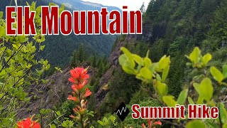
Shared By:

Greg B with improvements by Karl W

Trail Ratings

  4.0 from 2 votes

#13176

Overall
  4.0 from 2 votes
5 Star
50%
4 Star
0%
3 Star
50%
2 Star
0%
1 Star
0%
Trail Rankings

#424

in Oregon

#13,176

Overall
2 Views Last Month
757 Since Jun 1, 2018
Difficult Difficult

0%
0%
0%
50%
50%
0%

Photos

You'll know you have made it when you see the sign.
Jun 1, 2018 near Banks, OR
Hiking Elk Mountain Trail
Jun 20, 2020 near Banks, OR
A wide dirt track or road leads through douglas fir.
Jan 26, 2021 near Banks, OR

0 Comments

Weather


Current Trail Conditions

Unknown
Add Your Check-In

Check-Ins

Join the Community

Create your FREE account today!
Already have an account? Login to close this notice.

Get Started.