Dogs Leashed

Features
Birding · Commonly Backpacked · Fall Colors · Lake · River/Creek · Spring · Swimming · Views · Waterfall · Wildflowers · Wildlife

State parks close at dusk.
Overview
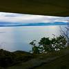
This is the best way to hike from Deception Pass to the Keystone Ferry. With stunning views such as beaches, birds, lakes, beaches, bridges, forts, beaches, mountains, beaches, farmland, and more beaches, you won't be disappointed along the way!
Need to Know
CHECK TIDE CHARTS—large portions of the trail are on the beach; if the tides don't line up take West Beach Rd.
NOAA tide charts:
tidesandcurrents.noaa.gov/n…
Bring money for the Keystone Cafe (across from ferry terminal). If you intend on taking the ferry to Port Townsend, here is a link to WSDOT website:
wsdot.com/ferries/schedule/…
Description
This is by far one of the best trails in the PNW. The whole trail runs from Montana to the Pacific Ocean. This portion of the PNNST embodies the trail before, and to come. From the mountain-like terrain at Deception Pass, to the beaches and farmland of the Ebey's Landing National Historical Preserve, you experience almost all of the varied terrain possible on the full trail (except for the snowy sections) in 33 miles. The trail passes through Coupeville and Oak Harbor; these towns are both filled with very friendly people, and lots of lodging options. There is also free transit throughout Island County, so if you need to catch a ride from the trail to town you can! If you have the chance, Seabolts is a wonderful local seafood joint—ask for the catch of the day!
Island Transit:
islandtransit.org/
Seabolts:
seabolts.com/
Directions:
After you get off the bridge, take a left onto the
Goose Rock Perimeter Trail. Follow that until you come to the cross trail of
Goose Rock Perimeter Trail and the
Discovery Trail; take a left, and follow this until you come out on Cornet Bay Rd. Take a left and follow the road until you come to a white gate. That is the beginning of
Cornet Bay Road. Follow this until you see a trail on your right, the
East Hoypus Point Trail. Take this until a you see a road on your left, Anglers Haven Drive. Follow this until the road ends on East Troxell Road. Take a left, and follow this road, it will merge onto Jones Road. Follow this until you reach a left hand turn onto Dike Road. Follow this until you reach East Frostad Road. Take a left, then take a right onto Taylor Road. Follow this until it merges onto East Fakema Road. Follow this until it dead ends on SR 20. Take a right, follow the highway until you see the two large plains, and take a left on Ault Field Road. Follow this until it merges into Clover Valley Road, follow this onto Golf Course Road. Follow this until it dead ends onto Crosby Road. Take a right, follow this until you see a trailhead for
Moyers Loop. Follow the trail to the parking lot. Make your way to the beach. Take a left, and follow the beach (or West Beach Road if tides are high) until you reach the ferry.
While the entirety of this trail is gorgeous, I will list a few of the best points.
1:
Deception Pass Bridge: This is the main attraction of Deception Pass State Park, causing the park to get nearly 3 million visitors a year! Words cannot express the beauty of the area.
2:
Cornet Bay Road viewpoint: If you have the time, head out to the end of
Cornet Bay Road, turn around and you'll have an unbeatable view of
Deception Pass Bridge.
3: Clover Valley and Dugualla Bay: When you are hiking down Dike Road, stop in the middle of the bridge. Take a look around you. Lush farmland to your right, and an expanse of ocean to your left, forest behind you, and hills in front of you. This is definitely one of the best views on the trail.
4: Joseph Whidbey: Once you reach the parking lot at Joseph Whidbey, you can see straight out to the ocean. You can see the Olympic Mountains, The Cascades, Mt. Rainier (on a good day), Mt. Baker, and Canada.
5: The whole thing.
Other land managers and organizations that take care of this part of the trail are:
More information can be found about the
PNT can be found
here.
Happy Trails!
Flora & Fauna
Ferns, pines, deer, seaweed, seals, whales, etc.
History & Background
Passes through: Deception Pass State Park, Dugualla State Park, Joseph Whidbey State Park, Ebey's Landing National Historical Reserve, Ebey's Landing State Park, Fort Ebey State Park, and last but not least
Fort Casey State Park.
Contacts
Shared By:
Isaac Bozeman

 Continue with onX Maps
 Continue with Facebook


 Particularly Special Place


 Difficult

 Deception Bridge and Goose Rock

 Anacortes, WA
 Barnum Point Preserve Loop Trail
 Oyster Dome Loop


0 Comments