
 Continue with onX Maps
 Continue with Facebook


 Particularly Special Place


 Difficult
Difficult
Difficult
 Difficult
Land Manager: Greater Wellington Regional Council
 Polhill Reserve Loop
4.4 mi 7.1 km • 658' Up 200.45 m Up • 656' Down 200.09 m Down

 Kelburn, NZ
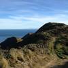
 Wellington Hills: Tip Track - Red Rocks
8.7 mi 14.0 km • 1,591' Up 484.96 m Up • 1,590' Down 484.74 m Down
Brooklyn, NZ
 Jumbo Holdsworth Loop
13.9 mi 22.3 km • 4,161' Up 1268.26 m Up • 4,163' Down 1268.99 m Down
Masterton, NZ
S-K Traverse
49.5 mi 79.7 km • 19,509' Up 5946.3 m Up • 19,825' Down 6042.51 m Down
Levin, NZ


0 Comments