
 Continue with onX Maps
 Continue with Facebook


 Particularly Special Place


 Intermediate/Difficult
Intermediate/Difficult
Intermediate/Difficult
 Intermediate/Difficult
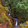
 Ladder Creek Falls
0.5 mi 0.8 km • 116' Up 35.42 m Up • 116' Down 35.31 m Down

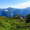
 Ptarmigan Traverse
32.9 mi 53.0 km • 10,892' Up 3319.76 m Up • 13,022' Down 3969.13 m Down
Diablo, WA
 Cascade Pass to Sahale Arm
11.7 mi 18.8 km • 3,898' Up 1187.97 m Up • 3,897' Down 1187.82 m Down
Diablo, WA
Pacific Crest Trail: Harts Pass to Rainy Pass
31.1 mi 50.0 km • 4,484' Up 1366.86 m Up • 5,765' Down 1757.22 m Down
Diablo, WA
Copper Ridge Loop
35.4 mi 57.1 km • 8,660' Up 2639.55 m Up • 8,658' Down 2638.84 m Down
Peacefu…, WA
Frosty Mountain Trail
13.3 mi 21.4 km • 3,846' Up 1172.27 m Up • 3,846' Down 1172.19 m Down
Princeton, BC


0 Comments