Dogs Unknown

Features
Birding · Views · Wildlife
Need to Know
If you intend to hike the entire length of the trail, it is probably best to stage a vehicle at one end. Bring plenty of water during hot days; there are very limited water sources along this stretch.
Description
Follow the yellow plastic diamonds.
This trail starts on the summit of Cotton Mountain and heads northeast to its end at Sandwich Notch Road. The trail travels nearly a mile to the junction with
Prescott Trail (on the right). It turns left and ascends to the summit of Mount Livermore by a series of switchbacks and passes
Old Mountain Road (on the right) near 1.5 miles and
Brooks Fisher Trail (on the left) around 2.4 miles.
The trail passes to the left of Mount Webster along the ridgeline. There isn't an official trail to the summit of Mount Webster, but there was a stack of rocks to mark its location. It reaches
Mount Morgan Trail and coincides with this trail for a short ways. It looks like the Crawford-Ridgepole Trail follows the most direct route along the
Mount Morgan Trail, which bypasses the ladders. The Crawford-Ridgepole Trail turns right off the
Mount Morgan Trail, at the sign to the summit and continues for another 0.8 miles to the summit of Mount Percival.
From here, the trail becomes much less-used; it is in desperate need of some maintenance. The trail runs over rocky ridges and open areas. The summit of Mount Squam isn't marked. The trail traverses up and over rocky ridgelines and dips into hardwood forests until it reaches
Doublehead Trail (on the right). The trail continues to follow the ridgeline over the summit of Doublehead Mountain. It descends, then ascends over some unnamed peaks before descending over a tricky rock wall, then steadily to its end at Sandwich Notch Road. There isn't any good parking on this side.
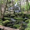
Taking the road right a short distance will lead you to a trailhead for the Bearcamp
River Trail. Beede Falls and Cow Cave are worth seeing, while you're in the area. This portion of the Bearcamp
River Trail provides a direct route to the Mead Base Camp.
Contacts
Shared By:
David Smith

 Continue with onX Maps
 Continue with Facebook


 Particularly Special Place


 Intermediate/Difficult

 4.3 (3)


0 Comments