
 Continue with onX Maps
 Continue with Facebook


 Particularly Special Place


 Intermediate/Difficult
Intermediate/Difficult
Intermediate/Difficult
 Intermediate/Difficult
Land Manager: GA Department Natural Resources
 Len Foote Hike Inn Loop
10.1 mi 16.3 km • 1,802' Up 549.37 m Up • 1,812' Down 552.36 m Down

 Long Creek Falls
2.0 mi 3.2 km • 264' Up 80.42 m Up • 264' Down 80.39 m Down
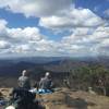
Indian Seats Loop
3.9 mi 6.2 km • 502' Up 153.12 m Up • 502' Down 153.1 m Down
 Neels Gap - Lake Winfield Scott Traverse
6.2 mi 10.0 km • 1,416' Up 431.71 m Up • 1,615' Down 492.29 m Down
 Blairsv…, GA
Boling Creek Park Trails
Blairsv…, GA
Boling Creek Park Trails
4.2 mi 6.7 km • 490' Up 149.36 m Up • 489' Down 149.16 m Down
Emery Creek Falls
5.9 mi 9.5 km • 690' Up 210.17 m Up • 689' Down 209.99 m Down
Chatsworth, GA


 All Clear


0 Comments