
 Continue with onX Maps
 Sign in with Facebook


 Particularly Special Place


 Intermediate
Intermediate
Intermediate
 Intermediate
Land Manager: National Park Service - Grand Canyon National Park
 Bright Angel Point
0.9 mi 1.4 km • 123' Up 37.47 m Up • 123' Down 37.53 m Down

 Grand C…, AZ
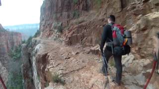
 Rim-to-River via South Kaibab
14.8 mi 23.9 km • 5,131' Up 1563.87 m Up • 5,131' Down 1564.02 m Down
Grand C…, AZ
Rim-to-River via Bright Angel
16.1 mi 25.9 km • 4,392' Up 1338.8 m Up • 4,393' Down 1338.84 m Down
Grand C…, AZ
Rim Trail to Mohave Point
3.1 mi 5.0 km • 849' Up 258.9 m Up • 827' Down 252.2 m Down
Grand C…, AZ
Grandview Trail to Horseshoe Mesa
5.4 mi 8.8 km • 2,489' Up 758.65 m Up • 2,494' Down 760.19 m Down
Grand C…, AZ
Hermit Trail to Hermit Creek
17.8 mi 28.6 km • 5,634' Up 1717.34 m Up • 5,636' Down 1717.81 m Down
Grand C…, AZ


0 Comments