
 Continue with onX Maps
 Continue with Facebook


 Particularly Special Place


 Intermediate/Difficult

 Intermediate/Difficult
Land Manager: Dunedin City Council, Dunedin, NZ
 Pineapple Track to Flagstaff Summit
4.9 mi 7.9 km • 1,603' Up 488.54 m Up • 1,602' Down 488.4 m Down
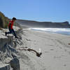
 Boulder Beach
1.7 mi 2.7 km • 346' Up 105.43 m Up • 347' Down 105.73 m Down
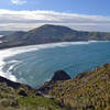
 Okia Reserve to Victory Beach
6.8 mi 10.9 km • 114' Up 34.86 m Up • 103' Down 31.32 m Down
Sandfly Bay from Seal Point Road
0.9 mi 1.5 km • 306' Up 93.15 m Up • 306' Down 93.2 m Down
Lovers Leap and The Chasm
1.6 mi 2.6 km • 376' Up 114.69 m Up • 374' Down 113.87 m Down
 Heyward Point
3.8 mi 6.0 km • 1,287' Up 392.3 m Up • 1,287' Down 392.27 m Down
Portobello, NZ


0 Comments