
 Continue with onX Maps
 Continue with Facebook


 Particularly Special Place


 Intermediate/Difficult

 Intermediate/Difficult
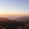
 Montara Mountain from Gray Whale Cove
9.9 mi 16.0 km • 1,758' Up 535.69 m Up • 1,758' Down 535.78 m Down
 Montara, CA
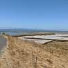
 Cowell Ranch Beach
1.1 mi 1.8 km • 82' Up 25.09 m Up • 83' Down 25.18 m Down
 El Corte de Madera Highlights
5.2 mi 8.3 km • 789' Up 240.35 m Up • 783' Down 238.69 m Down
Woodside, CA
Wunderlich Loop
10.3 mi 16.5 km • 1,850' Up 563.8 m Up • 1,846' Down 562.68 m Down
Alambique Loop Trail
1.8 mi 2.9 km • 343' Up 104.68 m Up • 341' Down 104.07 m Down
Woodside, CA
Coyote Hills Half Marathon Loop
13.1 mi 21.1 km • 133' Up 40.45 m Up • 133' Down 40.41 m Down


0 Comments