Dogs Leashed

Features
Views · Wildlife
Overview
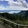
Views of Seattle skyline and Mount Rainier, check. Majestic Pacific Northwest forests, check. Views of the Olympic Mountains, check. This trail has it all.
Need to Know
For hikers looking for a longer day hike, the trail can be done as and out-and-back. For a nice 5-mile point-to-point, leave a second vehicle at Battle Point Park or arrange a pickup there.
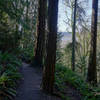
Description
It's easiest to start this trail from the east side of the island as there is a small parking lot at the beginning of the trail on Manitou Beach. While here, enjoy the views of the Seattle skyline and Mount Rainier before you start your hike. There are no trail markers at the start so just hike west along Manitou Beach Road uphill until you reach Madison Road. This short section is the least enjoyable part of the hike as it is a very busy junction ahead. Follow Madison Road west until you get to Highway 305. The crosswalk for 305 is on the right side of the road, so cross carefully since there are cars entering and exiting from multiple directions.
Once you cross 305, follow the short trail that brings you to Wardell Road. Things get much quieter from this point on as the roads here are much less traveled. When you get to the end of Wardell Road, follow the short, steep section onto McRedmond Lane. At the end of McRedmond Lane is the entrance to the Grand Forest East. For a short detour take a left onto Summer Hill Lane before entering the forest and say hello to the goats and miniature ponies at the nearby farm.
Back on the trail, enjoy the short flat section, because things quickly get pretty steep as you approach the
Grand Forest East Main Loop. Once your reach the main loop, take a right and then a left at the the fork immediately afterwards. The trail is pretty well marked on this section of the trail so just keep an eye out for the Cross Island Trail logos at each junction. When you get to the end of this trail, you be at the west side of the main loop trail. Take a left and then after a short hike you'll be at the junction of the
Hilltop Trail. Take a right onto this trail and follow it up to the clearing on the Hilltop. On a clear day, you should be greeted with a nice view of the Olympic Mountains ahead. If nature calls, there's a nice set of bathrooms available here, so take advantage.
Back on the trail, continue west and follow the steep downhill trail into Grand Forest West. Continue to follow the Cross Island Trail logos which will bring you to the
Grand Forest West Main Loop. You'll take a right onto this trail and then an immediate left and cross a small wooden bridge. After the bridge, continue straight along the trail which cuts through the forest to the west side of the main loop trail. Take a right here until you get to the parking area along the side of Miller Road.
From this point, you'll be leaving the Grand Forest and entering the
Forest to Sky Trail on the other side of Miller Road. This trail is mostly downhill in this direction as you follow along to Battle Point Park. Once you exit the woods follow the trail to the right into the park. As you continue, you'll see one last trail marker by the pond. Things get a bit trickier from this point on as the trail junctions are no longer marked. Follow the trail through the main parking lot of the park and up north until you get to another junction at a small pond. Take a right onto this trail and follow along until you get to the parking lot on the north side of the park.
Cross the parking lot and hike east along Frey Ave shortly until you see the Fairy Dell trail entrance. It's a short hike along this trail until you approach the end at Arrow Point. On a clear day you should have a great view of the Olympic Mountains waiting for you to reward your effort.
Contacts
Shared By:
Terrence Beach Jr

 Continue with onX Maps
 Continue with Facebook


 Particularly Special Place


 Intermediate

 Union Bay Loop


 Saint Edward State Park - Outer Loop
 Belvedere to Talus Round-Trip


0 Comments