
 Continue with onX Maps
 Continue with Facebook


 Particularly Special Place


 Intermediate/Difficult
Intermediate/Difficult
Intermediate/Difficult
 Intermediate/Difficult
Land Manager: USFS - Umpqua National Forest Office
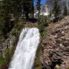
 Cottonwood Creek Falls
14.7 mi 23.6 km • 2,721' Up 829.47 m Up • 2,721' Down 829.31 m Down

 Crater…, OR
 Tenas Peak Loop
13.0 mi 20.9 km • 2,303' Up 702.03 m Up • 2,303' Down 701.86 m Down
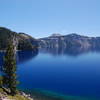
 Cleetwood Cove Trail
2.1 mi 3.4 km • 619' Up 188.58 m Up • 619' Down 188.69 m Down
Crater…, OR
Wizard Island Summit Trail
2.5 mi 4.0 km • 736' Up 224.3 m Up • 736' Down 224.2 m Down
Crater…, OR
Diamond Peak Loop
24.8 mi 39.9 km • 2,816' Up 858.18 m Up • 2,817' Down 858.65 m Down
Oakridge, OR
Odell to Windigo Loop
54.6 mi 87.8 km • 6,018' Up 1834.37 m Up • 6,019' Down 1834.59 m Down


0 Comments