Use onX Backcountry to explore the terrain in 3D, view recent satellite imagery, and more.
Now available in onX Backcountry Mobile apps!
For more information see this post.
Bison range freely throughout the park so you might encounter them on any of the trails. Keep at least 50 yards from them to avoid being charged (by the bison or the park police).
Description
This trail runs through the valley of the North Prong of the Little Red River and is 3-4 feet wide its entire length. It crosses the "river" half a dozen times and the trail runs directly through the river bed for a couple hundred feet in a couple of places. The "river" was dry when I hikeed, but you wouldn't want to hike it if there was any chance of a flash flood.
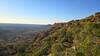
This trail is extremely sandy. The short little ascents/descents down into the river bed are particularly sandy. At about 2.0 miles, you'll leave the riverbed and after a short climb, you'll crest a hill and an awesome view of the red rock canyons to the west opens up. The path also becomes less sandy at this point, so you can make better progress.
We use cookies to improve your browsing experience, to show you
personalized content, and for statistical purposes. By continuing
to navigate our website, you accept our use of cookies. Read our
Privacy Policy to learn more.

 Continue with onX Maps
 Continue with Facebook


 Particularly Special Place


 Intermediate


0 Comments