
 Continue with onX Maps
 Continue with Facebook


 Particularly Special Place


 Intermediate
Intermediate
Intermediate
 Intermediate
Land Manager: Parks Victoria - Dandenong Ranges National Park
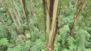
 Kalorama-Doongalla Loop
7.1 mi 11.4 km • 1,405' Up 428.27 m Up • 1,338' Down 407.74 m Down

 Kalorama, AU
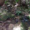
 Olinda Falls, Valley & Eagle Nest Loop
8.7 mi 14.0 km • 1,264' Up 385.4 m Up • 1,260' Down 383.99 m Down
Olinda, AU
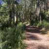
Sassafras to Emerald Walking Track
11.7 mi 18.8 km • 633' Up 193.02 m Up • 1,166' Down 355.35 m Down
Olinda, AU
East Sherbrooke Forest Walk
4.3 mi 6.8 km • 604' Up 184.1 m Up • 599' Down 182.54 m Down
 Kokoda Track (1000 Steps Walk)
2.4 mi 3.8 km • 939' Up 286.09 m Up • 937' Down 285.71 m Down
Ferny C…, AU
 Tan Track
2.5 mi 4.0 km • 128' Up 39.06 m Up • 126' Down 38.5 m Down


0 Comments