
 Continue with onX Maps
 Continue with Facebook


 Particularly Special Place


 Easy/Intermediate
Easy/Intermediate
Easy/Intermediate
 Easy/Intermediate
Land Manager: California State Parks - Trione-Annadel State Park
 Mount Hood via Goodspeed Trail
6.1 mi 9.9 km • 1,982' Up 604.24 m Up • 1,982' Down 604.15 m Down

 Kenwood, CA
 Bald Mountain Loop
7.0 mi 11.2 km • 1,794' Up 546.68 m Up • 1,798' Down 547.92 m Down
Annadel Park Channel Drive Loop
5.0 mi 8.1 km • 671' Up 204.58 m Up • 667' Down 203.36 m Down
Taylor Mountain
5.1 mi 8.2 km • 1,155' Up 352.05 m Up • 1,154' Down 351.86 m Down
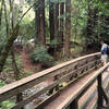
 Armstrong Redwoods Tour
2.1 mi 3.4 km • 200' Up 60.87 m Up • 199' Down 60.76 m Down
Guernev…, CA
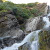
Zim Zim Falls
7.8 mi 12.5 km • 634' Up 193.17 m Up • 634' Down 193.16 m Down
Middletown, CA


0 Comments