
 Continue with onX Maps
 Continue with Facebook


 Particularly Special Place


 Difficult
Difficult
Difficult
 Difficult
Land Manager: USFS - George Washington & Jefferson National Forests
 Three Ridges Loop Trail
13.4 mi 21.6 km • 3,565' Up 1086.57 m Up • 3,564' Down 1086.44 m Down

 Nellysford, VA
Sherando Recreation Area Loop
Nellysford, VA
Sherando Recreation Area Loop
3.6 mi 5.9 km • 981' Up 298.96 m Up • 993' Down 302.61 m Down
Nellysford, VA
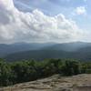
 Spy Rock Out-and-Back
6.0 mi 9.6 km • 925' Up 281.93 m Up • 924' Down 281.74 m Down
Nellysford, VA
Humpback Rocks Loop
4.2 mi 6.8 km • 1,117' Up 340.53 m Up • 1,132' Down 345.11 m Down
Nellysford, VA
Turk Mountain
10.5 mi 16.9 km • 2,384' Up 726.57 m Up • 2,361' Down 719.52 m Down
 Sugar Hollow Loop
18.5 mi 29.7 km • 2,709' Up 825.59 m Up • 2,727' Down 831.29 m Down


1 Comment