
 Continue with onX Maps
 Continue with Facebook


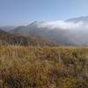
 Particularly Special Place


 Difficult
Difficult
Difficult
 Difficult
Land Manager: California State Parks - Point Mugu
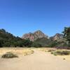
 Sycamore Canyon Loop
9.2 mi 14.8 km • 1,147' Up 349.66 m Up • 1,149' Down 350.16 m Down
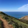
 Ray Miller at Pt. Mugu
5.5 mi 8.8 km • 964' Up 293.88 m Up • 963' Down 293.67 m Down
 Camarillo, CA
Reagan Ranch Loop
Camarillo, CA
Reagan Ranch Loop
3.9 mi 6.3 km • 650' Up 198.08 m Up • 650' Down 198.1 m Down
Cheeseboro Ridge & Cheeseboro Canyon Trail
10.3 mi 16.6 km • 1,199' Up 365.41 m Up • 1,199' Down 365.39 m Down
M.A.S.H Out-and-Back
4.8 mi 7.7 km • 226' Up 68.94 m Up • 226' Down 68.98 m Down
Agoura, CA
 Grand Tour
14.8 mi 23.8 km • 2,781' Up 847.79 m Up • 2,784' Down 848.55 m Down
Agoura, CA


 All Clear


0 Comments