
 Continue with onX Maps
 Continue with Facebook


 Particularly Special Place


 Intermediate/Difficult
Intermediate/Difficult
Intermediate/Difficult
 Intermediate/Difficult
Land Manager: USFS - Mt. Hood National Forest Office
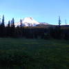
 Elk Meadows
6.0 mi 9.7 km • 1,061' Up 323.46 m Up • 1,058' Down 322.4 m Down

 Trillium Lake Loop Trail #761
1.9 mi 3.1 km • 17' Up 5.31 m Up • 17' Down 5.23 m Down
 Dog Mountain Trail #147
6.5 mi 10.4 km • 2,802' Up 853.98 m Up • 2,801' Down 853.86 m Down
 Carson, WA
Timothy Lake Loop
Carson, WA
Timothy Lake Loop
11.7 mi 18.8 km • 1,089' Up 331.96 m Up • 1,091' Down 332.58 m Down
Governm…, OR
 Catherine Creek
2.5 mi 4.1 km • 752' Up 229.1 m Up • 751' Down 228.87 m Down
PCT: Herman Creek to Eagle Benson
18.1 mi 29.1 km • 4,399' Up 1340.93 m Up • 4,399' Down 1340.8 m Down
Cascade…, OR


1 Comment