Hiking Project Logo

The Blue Ridge Parkway for trail those visitors who want a classic, mountain trail.


Your Rating: Rating Rating Rating Rating Rating      Clear Rating
Your Difficulty:
Your Favorites: Add To-Do · Your List
Zoom in to see details
Map Key

13.3

Miles

21.3

KM

Point to Point

4,669' 1,423 m

High

3,403' 1,037 m

Low

1,131' 345 m

Up

1,956' 596 m

Down

4%

Avg Grade (3°)

28%

Max Grade (16°)

Dogs Unknown

Features Birding · Cave · Fall Colors · Lake · River/Creek · Spring · Views · Waterfall · Wildflowers · Wildlife

Overview

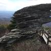
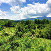
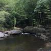
Built in 1993 at a cost of $750,000, The Tanawha Trail (Cherokee for fabulous hawk) is epic in every way. Expect everything from see-forever views atop craggy outcroppings to dense hardwood forests teaming with waterfalls. Beautiful bridges are photo worthy and make most creek crossings a breeze. Multiple access points along the always nearby Blue Ridge Parkway make it easy to shorten your trip or bail out if things are going poorly.

Description

Start at Beacon Heights, milepost 305.2 on the Blue Ridge Parkway. Most will do this as a one way journey. If so, leave another car or arrange for a ride from the traditional trail terminus near Price Lake. Stash this car either at Boone Fork Overlook, milepost 297.2 or Boone Fork Picnic Area, less than a mile further down the parkway. Reversing directions makes for a more strenuous journey.

Contacts

Land Manager: NPS - Blue Ridge Parkway

Shared By:

Eric Heistand

Trail Ratings

  4.6 from 19 votes

#2

in Grandfather

#579

Overall
  4.6 from 19 votes
5 Star
63%
4 Star
37%
3 Star
0%
2 Star
0%
1 Star
0%
Recommended Route Rankings

#2

in Grandfather

#579

Overall
27 Views Last Month
8,433 Since Mar 13, 2016
Difficult Difficult

0%
0%
5%
11%
84%
0%

Photos

Interesting rock formation next to the boardwalk protecting the delicate ecosystems on top of the ridge.
Mar 25, 2016 near Foscoe, NC
Elevated terrain with obstacles
Jun 14, 2020 near Foscoe, NC
Rainy day up in the clouds overlooking the trail to Lin cove
Jun 14, 2020 near Foscoe, NC
On the way up
Jul 22, 2020 near Linville, NC
Outcrop for a viewing and rest midway up.
Jul 22, 2020 near Linville, NC
The kid looking out
Aug 28, 2018 near Linville, NC
loading

Weather


Current Trail Conditions

All Clear 21 days ago
Add Your Check-In

Check-Ins

Mar 30, 2024
Kathleen Burroughs
13.4mi — 3h 31m
Mar 14, 2023
Selby Weeks
Sep 20, 2022
Jennifer Marquardt
From Price Park Picnic Area to Cold Prong Overlook and back. Love Holloway Mountain area!! 9.1mi
May 6, 2022
Michelle Hausman
Did full trail, parked at Beacon and Price Lake. Boulder Field section is not well marked, head straight across (NOT down) to catch the trail. 13.2mi — 8h 00m
Sep 23, 2020
Melissa Anderson
Stack rock to rough ridge; beautiful weather, sites and views! — 2h 50m
Jul 27, 2020
Todd Burgman
May 25, 2019
Mari Mycek
Mikal gluten 3.5mi — 2h 30m
Sep 8, 2018
Jack Bert P
Welcome

Join the Community

Create your FREE account today!
Already have an account? Login to close this notice.

Get Started