The longest trail in Government Canyon, secluded Black Hill Loop circles the Protected Habitat Area. The northern end starts at a large gate close to where
Sendero Balcones turns west. Singletrack and considerably smoother, at least at the beginning, the route heads off to the northeast on a mostly flat course. Some grass overgrowth helps cushion the path even further, making it a welcome break from the rocky trails that connect to it.
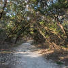
A greater variety of plant life is present along Black Hill Loop. Look for different types of cacti and some very large sotol plants. Black Hill is also much more open to the sky, with some nice large clearings to break up the forested sections. A few rocky sections add some changes, but they are not technical, making for an easy and fast first two miles.
At the mile and a half point, where the path turns back towards the trailhead, there is a huge cactus field to the left of the trail. Cave Creek
Trail is at the southern end of a large clearing just after this section. There are only brown markers to show where the trail splits off, so keep an eye out for a dirt singletrack branching to the right.
As Black Hill nears the two-mile point, a neighborhood is visible to the left. Not long after, the trail begins a quick descent followed by a half-mile climb, twisting frequently as it goes. The route is much more challenging through these sections, requiring some careful footwork to pick a clean line through the rocks which have started to appear. The more technical character of the trail will continue until the end, also throwing in some roots growing across the path which can catch an unsuspecting hiker's foot.
The marker for
La Subida Trail is parallel to the path and not easily seen, but there are markers for Black Hill on either side to help point it out. Some interesting yucca grow between the La Subida turnoff and the one for
Sendero Travesero a short time later, which is also easy to miss, as it is in the middle of a wide rocky washout area. A large cairn helps point the way.
A rough, bumpy descent finishes out the last mile of trail, as it passes an intersection with
Twin Oaks Trail and the western end of
La Subida Trail. This last segment is very similar to
Sendero Balcones, which is where Black Hill Loop finishes, directly across from the easy
Little Windmill Trail.
The Texas Hill Country is well known for its abundant tree life. Government Canyon exhibits a number of these varieties, including mountain laurel, Ashe juniper, mesquite and live oak. Birds and deer are the most common animals encountered in the area.

 Continue with onX Maps
 Continue with Facebook


 Particularly Special Place


 Intermediate/Difficult


0 Comments