Dogs No Dogs

Features
Birding · River/Creek · Views · Waterfall · Wildlife
Overview
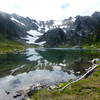
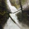
This long trail along the Quinault River winds its way through forests and rewards you at the end with the
Enchanted Valley. With its sheer cliffs and many waterfalls, it will be easy to see where the moniker "
Enchanted Valley" came from.
Need to Know
There are plenty of bears here so proper food storage is a must. Check in with the Quinault ranger station. This route spans a few USGS quads so look for a few alternatives that eliminate the multiple maps.
Description
The East Fork Quinault River Trail ascends the Quinault River drainage through some very big trees in this old forest. On the way back we bumped into a forester who showed us a place off trail where we could see old growth trees of three different species, so take the extra time to witness some of these ancient giants.
You can break this route up by camping along the way halfway up. While camping along the trail will give you a much more in depth experience, the trail is easily conquered in a single day.
Once you make your way up to the
Enchanted Valley, you see why it has earned the name. There are sheer cliffs across the Quinault, with hundreds of waterfalls streaming down it early in the season. You can spend a couple days in the valley exploring, and each day will be well worth your while.
Flora & Fauna
There are many bears in the area. We saw two in the valley walking across a snowpack on the opposite side of the river. There are also lots of elk that are usually present in the area.
Contacts
Shared By:
Steve Jackson

 Continue with onX Maps
 Continue with Facebook


 Particularly Special Place


 Intermediate/Difficult


")


0 Comments