Dogs Unknown

Features
Fall Colors
Need to Know
Parking location for Trail Run Project simply takes you to a crossing, not a parking lot. The "DeClue Trail Trailhead" is located at (38.527723, -90.683977). For runners, suggest going clockwise around the loop - majority of bikers go counter-clockwise.
Description
The DeClue Trail loop can be accessed from the south Allenton Six Flags Road, and from the north by passing Hencken road. From Allenton Road, parking is available on the left, and from Hencken Road, parking is the first stop on the right.
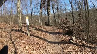
The natural trail is steep and rocky, and due to the steep terrain, the trail is fairly narrow. Visitors must use caution on this trail, as it is easy to get lost or to make a wrong turn. This trail overlaps with two other trails in park, the
Green Rock Trail, and the
Deer Run Trail. The overlap and the many intersections can be quite confusing.
Compared with the wooded landscapes in the areas surrounding the DeClue trail, the environment found off trail is fairly unique. A savannah and prairie ecosystem exists in the area, and typical grassland vegetation is present. Wildflowers and grasses dominate the landscape, and gnarled chinquapin oaks dot the landscape. Because this type of environ is suited to dry conditions, most local flora has evolved to take advantage of the conditions. Trees grow laterally, as there is rarely competition from other trees or shrubs that would force vertical growth.
Neither water nor modern restrooms can be found at the trailhead.
Contacts
Shared By:
St. Louis County Parks
with improvements
by Andrew Brandt

 Continue with onX Maps
 Continue with Facebook


 Particularly Special Place


 Intermediate/Difficult

 4.7 (12)


 All Clear


0 Comments