
 Continue with onX Maps
 Continue with Facebook


 Particularly Special Place


 Intermediate
Intermediate
Intermediate
 Intermediate
Land Manager: National Park Service - Mesa Verde National Park
 Point Lookout Trail
1.1 mi 1.7 km • 527' Up 160.75 m Up • 10' Down 3.16 m Down

 Mancos, CO
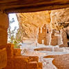
Balcony House Trail
Mancos, CO
Balcony House Trail
0.4 mi 0.7 km • 80' Up 24.43 m Up • 81' Down 24.8 m Down
Towaoc, CO
Long House Tour
2.2 mi 3.6 km • 236' Up 71.86 m Up • 241' Down 73.43 m Down
Towaoc, CO
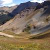
 Deadwood Mountain and Silver Mountain Extravaganza
9.6 mi 15.4 km • 3,977' Up 1212.07 m Up • 3,982' Down 1213.6 m Down
Mancos, CO
 Mancos Spur Trail
24.5 mi 39.5 km • 2,430' Up 740.77 m Up • 6,217' Down 1895.07 m Down
Rico, CO
 Colorado Trail (CT)
487.3 mi 784.3 km • 83,178' Up 25352.6 m Up • 81,864' Down 24952.2 m Down
Roxboro…, CO


0 Comments