
 Continue with onX Maps
 Continue with Facebook


 Particularly Special Place


 Difficult
Difficult
Difficult
 Difficult
Land Manager: NPS - Great Smoky Mountains National Park
 Spence Field Loop
13.7 mi 22.0 km • 3,125' Up 952.51 m Up • 3,125' Down 952.37 m Down

 Yellow Creek Falls
0.6 mi 0.9 km • 132' Up 40.34 m Up • 132' Down 40.33 m Down
 Robbins…, NC
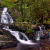
Spruce Flats Falls Trail
Robbins…, NC
Spruce Flats Falls Trail
1.8 mi 2.9 km • 452' Up 137.73 m Up • 452' Down 137.7 m Down
Gatlinburg, TN
 Lakeshore Tunnel Loop
3.2 mi 5.1 km • 690' Up 210.18 m Up • 641' Down 195.3 m Down
Deep Creek to Clingmans Dome
49.5 mi 79.6 km • 9,414' Up 2869.43 m Up • 9,410' Down 2868.3 m Down
Bryson…, NC
Deep Creek to Newton's Bald Loop
22.2 mi 35.7 km • 3,693' Up 1125.52 m Up • 3,692' Down 1125.42 m Down


2 Comments