Dogs Leashed

Features
Birding · River/Creek · Wildlife
Overview
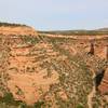
A great wilderness loop that is very navigable and provides a feeling of solitude despite being near Fruita/Grand Junction. This route is also loaded with historic features, geology and a great diversity of trail surfaces. The area is used by many, but most people stay within a mile of the parking lot. By venturing further into the canyons you often have the trail to yourself.
Need to Know
The dry wash is not always dry, so depending on the conditions and weather be prepared for some wet spots or tricky navigation to stay dry. If a summer storm is looming, best to avoid the washes all together due to flash flood potential.
Description
Start at the main Devil's Canyon Trailhead parking lot and head up the wide gravel road up
D1 - Devils Canyon. Stay left at the first fork, and then go right at the second junction following signs for
D1 - Devils Canyon and
D4 - Devils Canyon.
The trail will climb gradually and near the top of the rise you'll reach another junction. Go left to stay on
D4 - Devils Canyon as it begins winding down into the dry wash. You'll eventually meet up with the wash after a series of stone steps and then continue north up the on the Devils Canyon Loop - D3 trail.
Before you have to ascend the metamorphic basement rock there are two options, you can head left and have a shorter outbound segment, or go right (highly recommended) so you get the climbing done sooner, and once you reach the cabin your return trip will be shorter and faster.
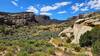
So, stay in the wash past the first junction and then climb up the steep but short hill to reach the plateau. The next section is a wonderful stretch of rolling terrain below steep cliffs as you make your way back into the canyon towards the cabin. The cabin is pretty obvious and can be fun to check out (be careful since it is old, unmaintained, and dilapidated), and when you are ready to finish the loop find the trail that heads downhill, to the west on the right side of the cabin. A couple of steep wash descents/ascents await and some of the best tower scenery comes on the return trip.
When you are back in the wash, continue past the
D4 - Devils Canyon junction on the left (which is easy to miss anyhow) and continue in the wash until it joins the obvious wide doubletrack of the D2 - Devils Canyon Trail. Head left and then stay right at the major junctions to follow the wide gravel path back to the parking lot.
Contacts
Shared By:
Andrew Walters
with improvements
by Kester Spindler

 Continue with onX Maps
 Continue with Facebook


 Particularly Special Place


 Intermediate/Difficult

 4.5 (19)


0 Comments