Dogs No Dogs

Features
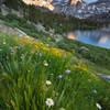
Birding · Fall Colors · River/Creek · Swimming · Views · Waterfall · Wildflowers · Wildlife

If you go beyond the base of Marble Falls, use caution. Water and slippery rocks are beautiful but dangerous.
Overview
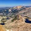
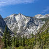
One of the most dramatic trails in the foothills, this route ends at Marble Falls. It provides views of some of the most rugged terrain in Sequoia National Park.
This trail climbs 3.9 miles (6km) through chaparral to a lovely cascade. Park near site #14 at Potwisha Campground. Follow the dirt road across the concrete ditch. The trail starts along the steep bank to the right.
Description
Marble Falls trailhead is located up a small service road near camp
Potwisha Campground Site #14.
Start on a service road for about 1/4 mile and make a right onto
Marble Falls Trail, which is well marked. Immediately the trail is a singletrack climb. Expect several switchbacks during the ascent, which provide some nice respite.
You'll come across several shaded areas that offer a variety of plant life such as oaks, cottonwoods, redbuds, and dogwoods. There are normally several small creek crossings, but during the 2015 drought the stream crossings are non-existent. Be careful, as there are lots of rocks and overgrown vegetation on the trail.
In its most simple form, this route is an out-and-back for about 3.5 miles one way (7 miles overall). Expect an elevation gain of 1470 feet to the falls. Once you arrived at the falls be careful as the rocks can be slippery.
Flora & Fauna
Oaks, cottonwoods, redbuds, and dogwoods.
Contacts
Shared By:
Al Morales

 Continue with onX Maps
 Continue with Facebook


 Particularly Special Place


 Intermediate

 4.4 (24)


0 Comments