Dogs Unknown

Features
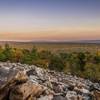
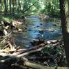
Birding · Fall Colors · Lake · River/Creek · Views · Wildlife

Camping prohibited on Penn State Forest property
Need to Know
Take caution crossing Rt. 26, especially at Jo Hays Vista. Camping is prohibited within the Penn State Stone Valley Forest property. Make sure to camp only on Rothrock State Forest property if using the trail as an overnight backpacking trip. Common parking areas include Jo Hays Vista, Woodcock Trail parking area within Stone Valley Forest, and Shaver's Creek Environmental Center. Do not park at Shaver's Creek Environmental Center if hiking in late afternoon, past dark or doing an overnight. They close the gate after 5:00pm daily.
Description
This description starts and ends at Jo Hays Vista along Rt. 26 traveling clockwise.
Start the trail by crossing Rt. 26 (Be Careful) and following the Mid-State Trail, which travels immediately down the South side of the mountain. Follow the steep downhill section to a trail intersection. Make a right turn and follow the yellow blazed Ironstone Trail. The trail meanders downhill over rolling terrain to the intersection with Pine Swamp Rd.
Make a right, crossing a small stream, and then veer to the left past a gate that leads to a cabin. Shortly after the cabin, the trail enters the property of the Penn State Forest and is marked by wooden tree markers with a symbol of an iron furnace. The trail makes a sharp turn to the left and travels down a steep hill to an old stone iron furnace, which is marked with an interpretive sign.
Past the iron furnace, cross Rt. 26 through a meadow and continue on the Ironstone Trail traversing along Shaver's Creek. The trail soon comes to the intersection with the Woodcock Trail, within the Penn State Stone Valley Forest. Make a left, continuing to follow the trail markers with the iron furnace symbol. Near the end of the Woodcock Trail, veer to the left to cross over Red Rose Rd. and continue on the Ironstone Trail.
The Woodcock Trail parking area can be seen from this point and can be used as another starting point. The Ironstone makes a left turn before coming to the intersection with the Upper Black Walnut Trail. Make a right and follow the Ironstone Markers.
The trail eventually comes to the intersection with the Lake Trail. A short side-trip to the left will take you to the Shaver's Creek Environmental Center where there are restrooms. The Ironstone makes a right and shares a path with the Lake Trail until making a right shortly after a powerline.
Cross Charter Oak Rd., make a left and travel through a pine and spruce forest. The trail leads to a gravel forestry road where you'll make a left and continue to follow yellow blazes on the forest road to the top of a mountain. The forest road ends and turns into a section of rocky singletrack before traveling down a long, steep downhill. Cross a small stream before coming to Harry's Valley Rd.
Travel up the steep stone steps of the Indian Steps Trail before gaining the ridge at the intersection of the Mid-State Trail. Make a right and follow the rocky MST past several scenic overlooks before ending at the Jo Hays parking lot.
Flora & Fauna
The trail travels primarily through mixed hardwood forest with sections of pine and spruce stands. A portion of the trail follows Shaver's Creek and you'll get views of Lake Perez at Penn State's Stone Valley Recreation Area. Deer, turkey, bear, and possibly rattlesnakes could be seen on the trail. You're guaranteed to see birds of prey by taking a short detour to Shaver's Creek Environmental Center and visiting the raptor center.
Contacts
Shared By:
Jason Erdman

 Continue with onX Maps
 Continue with Facebook


 Particularly Special Place


 Difficult

 Jackson Trail - Mid State Trail Loop

 Pine Gr…, PA
 Whipple Lake Trail
 Bear Meadows/Mid State Trail Loop
 Marsh Trail


0 Comments