
 Continue with onX Maps
 Continue with Facebook


 Particularly Special Place


 Intermediate
Intermediate
Intermediate
 Intermediate
Land Manager: USFS - Los Padres National Forest Office
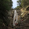
 San Ysidro Falls
3.6 mi 5.8 km • 1,031' Up 314.18 m Up • 1,030' Down 314.02 m Down


 Montecito Peak
7.0 mi 11.3 km • 2,352' Up 716.99 m Up • 2,352' Down 716.91 m Down
Canyon Loop
4.4 mi 7.0 km • 1,257' Up 383.04 m Up • 1,271' Down 387.33 m Down
Montecito, CA
 Inspiration Point and Seven Falls
3.8 mi 6.2 km • 916' Up 279.27 m Up • 915' Down 278.77 m Down
More Mesa Beach
1.2 mi 1.9 km • 99' Up 30.08 m Up • 99' Down 30.1 m Down
Santa Barbara Shores Loop
2.9 mi 4.7 km • 134' Up 40.93 m Up • 134' Down 40.97 m Down
Isla Vista, CA


0 Comments