
 Continue with onX Maps
 Continue with Facebook


 Particularly Special Place


 Very Difficult
Very Difficult
Very Difficult
 Very Difficult
Local Club: Randolph Mountain Club (RMC)
Apr 3, 2024: Spring Hiking and Eclipse Viewing: Take Extra Precautions
Land Manager: USFS - White Mountain National Forest Office
 Pinkham Notch to Mount Washington Summit
8.0 mi 12.8 km • 4,154' Up 1265.99 m Up • 4,152' Down 1265.6 m Down

 Pinkham…, NH
Four Summits Loop (Tom, Field, Willey, Avalon)
Pinkham…, NH
Four Summits Loop (Tom, Field, Willey, Avalon)
9.3 mi 14.9 km • 3,325' Up 1013.38 m Up • 3,325' Down 1013.39 m Down
Pinkham…, NH
Mt. Crag
2.3 mi 3.7 km • 640' Up 195.09 m Up • 640' Down 194.96 m Down
Gorham, NH
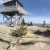
 Mount Kearsarge North Trail
5.8 mi 9.4 km • 2,485' Up 757.4 m Up • 2,487' Down 758.04 m Down
North C…, NH
Bald Mountain/Artists Bluff Loop
1.5 mi 2.4 km • 535' Up 163.11 m Up • 532' Down 162.09 m Down
Franconia, NH
 Bald Mountain Out-and-Back
0.6 mi 1.0 km • 243' Up 74.02 m Up • 243' Down 73.94 m Down
Franconia, NH


0 Comments