
 Continue with onX Maps
 Continue with Facebook


 Particularly Special Place


 Intermediate


 Intermediate
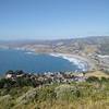
 Pedro Point Headlands Loop
2.3 mi 3.7 km • 481' Up 146.73 m Up • 481' Down 146.51 m Down
Pacifica, CA
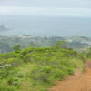
Sweeny Ridge Loop
5.7 mi 9.1 km • 954' Up 290.82 m Up • 958' Down 292.09 m Down
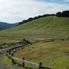
Water Dog Loop Trail
3.3 mi 5.3 km • 519' Up 158.34 m Up • 521' Down 158.71 m Down
San Carlos, CA
 Edgewood Nature Preserve Loop
5.7 mi 9.2 km • 1,034' Up 315.3 m Up • 1,028' Down 313.25 m Down
Emerald…, CA
Creeks to Peaks Trail
3.6 mi 5.9 km • 729' Up 222.24 m Up • 729' Down 222.12 m Down
Daly City, CA
 SF Crosstown Trail Route
16.9 mi 27.2 km • 1,993' Up 607.53 m Up • 1,856' Down 565.62 m Down
Brisbane, CA


0 Comments