Dogs Unknown

Features
Birding · River/Creek · Views · Waterfall · Wildflowers
Overview
The Rob Roy Glacier Track is one of Mount Aspiring National Park's most outstanding day-hikes. A relatively short and well-kept path leads high into the Rob Roy Basin, where a hanging glacier drapes the mountain walls and sends cascades of water down in all directions. The walk is beautiful the entire way, and the payoff view at the end is simply stunning.
Description
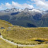
From the Raspberry Flats carpark, the Rob Roy track heads up the West Matukituki River valley through a grazed paddock with wide open views. Shortly thereafter, the track crosses the river via a fun swinging bridge and enters shady beech forest within Mount Aspiring National Park.
From here, the route heads up a cleft in the canyon wall carved by Rob Roy Stream, which thunders in the bottom of the gorge. The trail climbs, sometimes steeply, along the beautiful stream. At the signed lower viewpoint, there are awesome views of Bridal Veil Falls, which has an impressive uninterrupted drop of 261 meters (856 feet) from the base of the glacier above. This is only a taste of what is to come, and it is definitely worth continuing on another 30 minutes to the upper viewpoint, where the official trail stops at treeline.
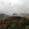
The view from trail's end is nothing short of awesome. Countless waterfalls cascade from the Rob Roy Glacier, craggy mountains are on all sides, and wildflowers fill the meadows. It is worth lingering here to take in the epic scenery before turning around and heading back the way you came.
Flora & Fauna
Kea are common at the top of this track - don't feed them!
Contacts
Shared By:
Almonzo Wilder

 Continue with onX Maps
 Continue with Facebook


 Particularly Special Place


 Intermediate

 4.6 (14)


0 Comments