
 Continue with onX Maps
 Continue with Facebook


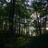
 Particularly Special Place


 Intermediate/Difficult
Intermediate/Difficult
Intermediate/Difficult
 Intermediate/Difficult
Local Club: Benton MacKaye Trail Association
Land Manager: USFS - Chattahoochee-Oconee National Forest
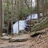
 Long Creek Falls
2.0 mi 3.2 km • 264' Up 80.42 m Up • 264' Down 80.39 m Down

 Blood Mountain Loop
6.6 mi 10.6 km • 1,424' Up 434.06 m Up • 1,422' Down 433.4 m Down
 Blairsv…, GA
 Coosa Backcountry
12.7 mi 20.4 km • 3,326' Up 1013.7 m Up • 3,311' Down 1009.17 m Down
Blairsv…, GA
Raven Cliffs Falls
5.5 mi 8.8 km • 895' Up 272.91 m Up • 895' Down 272.79 m Down
Cleveland, GA
Pinhoti 3
8.5 mi 13.6 km • 1,361' Up 414.93 m Up • 1,362' Down 415.14 m Down
Chatsworth, GA
Brasstown Bald via Jack's Gap
5.8 mi 9.3 km • 2,179' Up 664.28 m Up • 2,179' Down 664.01 m Down
Hiawassee, GA


 All Clear


2 Comments