
 Continue with onX Maps
 Continue with Facebook


 Particularly Special Place


 Intermediate
Intermediate
Intermediate
 Intermediate
Land Manager: City of Scottsdale
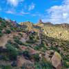
 Tom's Thumb
4.4 mi 7.1 km • 1,084' Up 330.45 m Up • 1,084' Down 330.28 m Down

 Rio Verde, AZ
 Apache Wash Trail Loop
6.8 mi 10.9 km • 218' Up 66.52 m Up • 219' Down 66.63 m Down
Phoenix, AZ
Camelback Mountain via Cholla Trail
3.2 mi 5.2 km • 1,193' Up 363.49 m Up • 1,190' Down 362.66 m Down
Paradis…, AZ
 North Top Summit
0.8 mi 1.4 km • 525' Up 160.05 m Up • 0' Down 0 m Down
 Double Butte Loop
2.3 mi 3.7 km • 115' Up 35.02 m Up • 117' Down 35.78 m Down
Maricopa Trail: Usery Mountain Visitor's Center to Bulldog
13.1 mi 21.1 km • 1,079' Up 328.87 m Up • 1,079' Down 328.94 m Down


 All Clear


0 Comments