
 Continue with onX Maps
 Continue with Facebook


 Particularly Special Place


 Easy/Intermediate
Easy/Intermediate
Easy/Intermediate
 Easy/Intermediate
Land Manager: USFS - Uinta, Wasatch & Cache National Forests Office
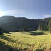
 Pipeline Trail: Burch Hollow, Millcreek Canyon
9.3 mi 15.0 km • 275' Up 83.8 m Up • 275' Down 83.85 m Down

 Mount O…, UT
 Deso-Crest-Dog Loop
12.9 mi 20.8 km • 2,770' Up 844.37 m Up • 2,769' Down 843.89 m Down
Alta, UT
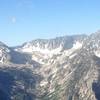
 Broads Fork Twin Peaks
9.6 mi 15.4 km • 5,325' Up 1622.93 m Up • 5,324' Down 1622.68 m Down
Cottonw…, UT
Lookout Peak from Killian's
9.9 mi 16.0 km • 3,024' Up 921.84 m Up • 3,024' Down 921.67 m Down
Mount Wire via George's Hollow
4.4 mi 7.1 km • 2,095' Up 638.61 m Up • 2,095' Down 638.64 m Down
Armstrong Spiro Loop
9.0 mi 14.5 km • 1,519' Up 462.95 m Up • 1,552' Down 472.96 m Down


 All Clear


0 Comments