
 Continue with onX Maps
 Continue with Facebook


 Particularly Special Place


 Intermediate
Intermediate
Intermediate
 Intermediate
 Cache Creek Ford
13.1 mi 21.1 km • 1,543' Up 470.38 m Up • 2,288' Down 697.3 m Down
 Clearlake, CA
 Craig Canyon-Thompson Canyon Loop
9.8 mi 15.7 km • 1,309' Up 398.9 m Up • 1,309' Down 398.9 m Down
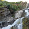
Zim Zim Falls
7.8 mi 12.5 km • 634' Up 193.17 m Up • 634' Down 193.16 m Down
Middletown, CA
Snow Mountain Summits
9.5 mi 15.3 km • 2,131' Up 649.55 m Up • 2,131' Down 649.52 m Down
Lucerne, CA


0 Comments