
 Continue with onX Maps
 Continue with Facebook


 Particularly Special Place


 Difficult
Difficult
Difficult
 Difficult
Land Manager: NPS - Great Smoky Mountains National Park
 Indian Creek to Deep Creek Loop
10.6 mi 17.0 km • 1,697' Up 517.37 m Up • 1,687' Down 514.05 m Down


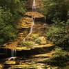
 Juney Whank Falls
0.6 mi 0.9 km • 122' Up 37.16 m Up • 125' Down 38.08 m Down
 Deep Creek to Clingmans Dome
49.5 mi 79.6 km • 9,414' Up 2869.43 m Up • 9,410' Down 2868.3 m Down
Bryson…, NC
Deep Creek to Newton's Bald Loop
22.2 mi 35.7 km • 3,693' Up 1125.52 m Up • 3,692' Down 1125.42 m Down
 Andrews Bald Out and Back
3.6 mi 5.8 km • 806' Up 245.82 m Up • 807' Down 246.08 m Down
Bryson…, NC
Grotto Falls
2.6 mi 4.2 km • 515' Up 157.07 m Up • 516' Down 157.18 m Down
Gatlinburg, TN


3 Comments