Dogs Off-leash

Features
Fall Colors · Views
Overview
This is what mountain hiking is all about. Start with some uphill hiking on trails. Then throw in a mountain ridge that takes you to one of the most prominent peaks in the Mammoth Lakes area. Descend back to the trails and cap off the day with some fast downhill splits—if you still have the energy!
Need to Know
The ridge is most accessible for hikers when free of snow in late summer or fall. If you go when there is snow along the ridge, take appropriate gear (e.g., ice axe) for a snow climb. In the winter, it is a popular destination for backcountry skiers and snowboarders. There are no reliable water sources along the route, so carry what you'll need for the round-trip—or take a detour to Laurel Lakes to filter some water.
Description
To get there, take Highway 395 south from Mammoth and turn right on Sherwin Creek Road. Drive along this dirt road for a few miles until you reach Laurel Lakes Road. Park here and get ready to hike.
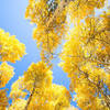
Follow Laurel Lakes Road as it switchbacks up the hillside and disappears into the valley. After climbing about a mile and a half, the trail flattens out a bit and takes you through a grove of aspen trees. After about three miles from the start, the grade steepens again with another set of switchbacks.
At about 4.25 miles from the start, keep your eyes open for a trail on the left side of the road. It can be easy to miss as there are no trail markers. Take this trail (the
Laurel Lakes - Edith Lake Trail) and follow it up the hillside to the saddle between Laurel Mountain (to your left) and Bloody Mountain (to your right).
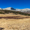
From the saddle, leave the trail and head toward the ridge of Bloody Mountain. Here you'll pick up a faint but visible use trail that will lead you all the way to the summit. But first, you must navigate the ridgeline and a few false summits along the way.
As you begin the ascent along the ridge, the true summit will be hidden from view. But keep at it, and you'll soon find yourself standing on the summit and enjoying the spectacular panorama.
Contacts
Shared By:
Adam Hodges

 Continue with onX Maps
 Continue with Facebook


 Particularly Special Place


 Very Difficult


0 Comments