
 Continue with onX Maps
 Continue with Facebook


 Particularly Special Place


 Intermediate
Intermediate
Intermediate
 Intermediate
Land Manager: USFS - George Washington and Jefferson National Forest
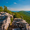
 Big Schloss from Wolf Gap
4.6 mi 7.3 km • 986' Up 300.44 m Up • 993' Down 302.72 m Down

 Moorefield, WV
 Kennedy Peak Out-and-Back
5.3 mi 8.6 km • 755' Up 230.23 m Up • 756' Down 230.33 m Down
Signal Knob
10.6 mi 17.1 km • 2,098' Up 639.37 m Up • 2,136' Down 650.93 m Down
Strasburg, VA
Eagle Rock
8.1 mi 13.0 km • 1,049' Up 319.76 m Up • 1,049' Down 319.68 m Down
Neighbor Mountain - Jeremys Run Loop
14.0 mi 22.5 km • 2,503' Up 762.95 m Up • 2,509' Down 764.82 m Down
Whiteoak Canyon to Upper Falls
4.7 mi 7.5 km • 941' Up 286.93 m Up • 942' Down 287.04 m Down
Stanley, VA


0 Comments