
 Continue with onX Maps
 Continue with Facebook


 Particularly Special Place


 Intermediate

 Intermediate
Local Club: Boy Scout Troop 801 - Brea, CA
Land Manager: California State Parks: Chino Hills
 South Ridge and Telegraph Canyon Loop
7.0 mi 11.3 km • 830' Up 253.09 m Up • 830' Down 253.1 m Down
 Santiago Creek to Robber's Roost
3.4 mi 5.5 km • 647' Up 197.17 m Up • 647' Down 197.08 m Down
Peter's Canyon Loop
5.4 mi 8.6 km • 419' Up 127.76 m Up • 418' Down 127.38 m Down
Crystal Cove Loop
9.7 mi 15.6 km • 1,081' Up 329.55 m Up • 1,081' Down 329.64 m Down
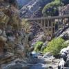
 Bridge to Nowhere - East Fork Trail #8W13
9.8 mi 15.8 km • 814' Up 248.01 m Up • 814' Down 248.01 m Down
La Verne, CA
Stagecoach South Intermediate Loop
7.8 mi 12.6 km • 958' Up 291.88 m Up • 957' Down 291.78 m Down
Laguna…, CA


 All Clear


0 Comments