Use onX Backcountry to explore the terrain in 3D, view recent satellite imagery, and more.
Now available in onX Backcountry Mobile apps!
For more information see this post.
So this trail is shown on the park map and if you look hard enough, you can tell where the doubletrack runs (or used to run). When I traveled it, the part from the northern gate to Fractures in the Rock Spur was mowed and easily followed. The center portion between Fractures in the Rock Spur and Rock Garden Trail was difficult to find with grass standing three feet tall in some places.
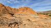
Southeast of the intersection with Rock Garden Trail, the doubletrack was well-established, and following the trail to the end leads to a grand viewpoint of the undeveloped area of the park. The various spur trails shown on the park map running to the cliff edge were very poorly (if at all) defined with the exception of Fractures in the Rock Spur.
The trail can only be accessed using the difficult Rock Garden Trail and hikers who enjoy The Rock Garden Trail are likely to find this Rylander Fortress Cliff Trail uninteresting.
There are gates going to private property at the northern terminus and mile 2.5.
We use cookies to improve your browsing experience, to show you
personalized content, and for statistical purposes. By continuing
to navigate our website, you accept our use of cookies. Read our
Privacy Policy to learn more.

 Continue with onX Maps
 Continue with Facebook


 Particularly Special Place


 Easy
Easy


0 Comments