Dogs No Dogs

Features
Views · Wildflowers

Please be aware of rapidly changing weather. Flash flooding is a serious risk and can occur even if it's not raining in your immediate vicinity.
Description
While visiting National Parks can be an eye-opening experience, it is often difficult to find solitude. However, on this faint trail, there is plenty of solitude to go around, in addition to stellar views of a changing desert landscape.
While the elevation of this trail is mellow, the soft sand makes for slow hiking for most of the way. Starting out from the trailhead, the trail is flat, and lined with desert grasses and wildflowers. This first portion is quite scenic, and even those who only want to dabble in desert navigation will enjoy the first few miles. Stopping at the Stubbe Spring itself is a great destination, and the lush valley that surrounds the spring is a verdant surprise. Many will turn back here, but continuing on the rest of the loop is a great way to continue your desert journey.
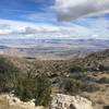
As you continue, you'll leave the sandy flats behind and will begin climbing into a few small foothills. The going will be a bit steeper, but grades remain manageable through the duration of the trail. After a wash crossing, the trail will mellow into rolling hills. From here out, the vegetation is less grassy than it is dominated by by pinyons and junipers. After ascending to a high point just past 4 miles, the rest of the hike is a slight drop back to the road, where it is an easy hike back to your car.
Flora & Fauna
Joshua trees, wildflowers, desert grasses, and finally Pinyon pines and juniper can all be observed on this route.
Contacts
Shared By:
Trail Master

 Continue with onX Maps
 Continue with Facebook


 Particularly Special Place


 Intermediate

 4.5 (8)


0 Comments