
 Continue with onX Maps
 Continue with Facebook


 Particularly Special Place


 Easy/Intermediate
Easy/Intermediate
Easy/Intermediate
 Easy/Intermediate
Land Manager: Fairfax County, VA - Park Authority
 Billy Goat Trail C Loop
2.9 mi 4.6 km • 140' Up 42.52 m Up • 139' Down 42.28 m Down

 Cabin John, MD
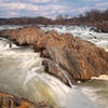
 Great Falls Overlooks Out and Back
3.8 mi 6.1 km • 45' Up 13.72 m Up • 45' Down 13.65 m Down
TRACK Trail
1.9 mi 3.1 km • 19' Up 5.66 m Up • 19' Down 5.7 m Down
Rock Creek Park Loop: Western Ridge to Valley Trails
8.8 mi 14.2 km • 484' Up 147.49 m Up • 485' Down 147.73 m Down
Glover-Archbold Trail
3.0 mi 4.9 km • 370' Up 112.89 m Up • 53' Down 16.25 m Down
 Roosevelt Island Loop
1.7 mi 2.7 km • 36' Up 10.93 m Up • 36' Down 10.85 m Down


0 Comments